Perhaps the story of Sarajevo’s turbulent past can best be told by strolling along the streets of this city on the Miljacka, for they bear silent testimony to regime changes, since the first thing new leaders did was change the names of Sarajevo’s streets.
The left bank of the river (facing west) is more residential and the right bank is for business
Sarajevo was founded in the middle of the 15th century by the Ottoman military leader, Isa Bey Ishaković. The street that bears his name is located in the Old Town, on the left bank of the Miljacka River and covers the area that has represented Sarajevo’s main core ever since the Emperor’s Mosque and surrounding neighborhoods were built.
Obala Isa Bey Ishaković starts at At Mejdan Park and Latinska Ćuprija and is connected to the right bank by Obala Kulina Bana and Zelenih Beretki Street, where the Sarajevo Assassination took place – an event that changed the course of history.
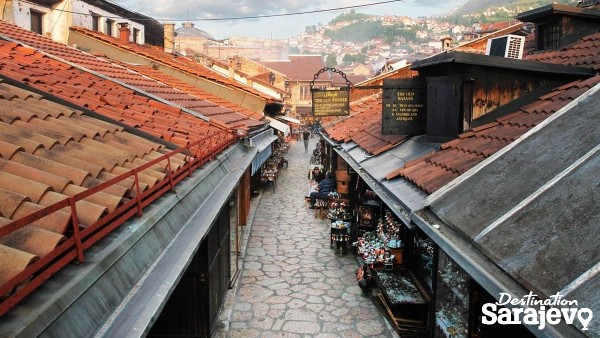
While Sarajevo’s residential areas were located on the left bank of the Miljacka during the Ottoman period, the right bank would become home to the city’s merchant and trading center – Čaršija – which enjoyed it’s golden age of development from the mid 16th century right up to the end of the 17th century.
The name Baščaršija comes from the Turkish (baš = head, main; čaršija = bazaar, trading area) and it originally referred to only the part around Baščaršija Square but, with time, it became a synonym for the entire cultural and historical core of Sarajevo.
The greatest contributing factor made to the development of Sarajevo in the middle of the 16th century was by the Ottoman Governor, Gazi Husrev Bey, who had numerous facilities built and which are now historical monuments: Gazi Husrev Bey’s Mosque and Bezistan, Sahat Kula, Kurshumli Medresa, Imaret, Tašlihan, Morića Han....
Along the eastern wall of Gazi Husrev Bey’s Bezistan lies Gazi Husrev Bey Street, known among Sarajevans as Zlatarska St., since it’s here that many goldsmith shops and filigree artisans can be found.
During the Ottoman period, artisans who belonged to a certain guild (esnaf) would share the same area on a single street or on other adjacent ones, which is why many streets in Baščaršija got names that were related to the artisans and trades that were found there.
While some of these trades are no longer around today, Baščaršija is still home to the following colorful street names: Abadžiluk, Aščiluk, Bravadžiluk, Čizmedžiluk, Ćurčiluk, Halači, Mudželiti, Kazandžiluk, Kujundžiluk, Sarači....
A new architectural style came with the arrival of Austro-Hungarian rule in 1878, a time which saw the formation of new streets with rows of Western-style, multi-story buildings.
The city where East and West meet
It was during this period that Sarajevo, as a city where East and West met, began to acquire a unique look and this is best seen at the spot known as “Sarajevo – Meeting of Cultures”. On one side is Sarači St., with its oriental charm, and on the other is Ferhadija St., with its elegant Western-style buildings.
It was with the construction of Sarajevo Cathedral during the Austro-Hungarian period that the city got its first square, in the classical sense. Trg Fra Grge Martića bisects Ferhadija and extends south to form Štrosmajerova Street, one of Sarajevo’s prettiest Austro-Hungarian streets.
Sarajevo’s most popular walking street, Ferhadija, continues west toward Trg Oslobođenja-Alija Izetbegović, which is named after the first President of independent BiH, and all the way to Maršala Tita Street. On April 6, 1946, the first anniversary of the liberation of Sarajevo during the Second World War, the street was named after Josip Broz Tito, President of the Socialist Federal Republic of Yugoslavia.
Maršala Tita Street continues to BBI Center, where it runs along the northern side of Trg Djece Sarajeva, a plaza which is named in memory of the children killed during the Siege of Sarajevo during the 1990s. The street ends at Trg Bosne i Herzegovina, at the buildings that house the Parliament Assembly and Council of Ministers of BiH.
It is exactly here, somewhere around Trg Bosne i Hercegovine in Marijin Dvor, that one can “see” the imaginary line between “old” Sarajevo and “modern” Sarajevo – this is a city that continues to grow and develop and every little street has its own interesting story to tell.